openlayers属性数据mysql_Openlayers+GeoServer+MySql获得JSON、GML数据的兼容性问题
问题
在使用OpenLayers4获得GeoServer数据时出现的一个问题:
if (currentSource.getGetFeatureInfoUrl) {
url = currentSource.getGetFeatureInfoUrl(evt.coordinate, viewResolution, viewProjection, {
'INFO_FORMAT': 'application/json'//vnd.ogc.gml
});
//向服务器发送请求,获得返回数据
$.get(url, function (data) {
var geoJSONReader = new ol.format.GeoJSON();
var feature = geoJSONReader.readFeatures(data)[0];
......
GeoServer连接的MySql数据库,空间数据包含Date类型的属性(如:’2017-11-2′)。
获得的feature的Date属性产生了错误:’2017-11-2Z‘,多了一个Z。
经过检查,发现get到的data中已经产生了该错误。
分析问题过程
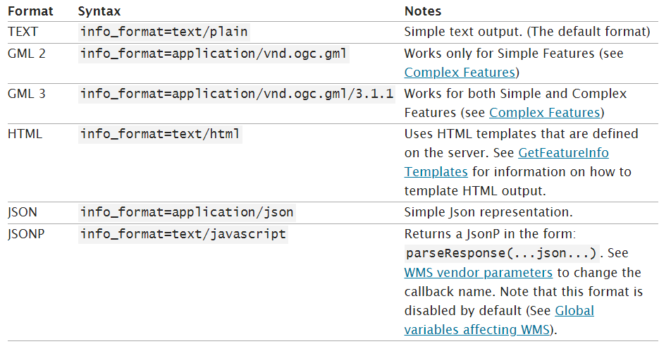
既然json格式对Date的支持不好,那就改变数据格式。查询GeoServer官网,发现getFeatureInfo方法支持的格式有:
经过测试GML2支持Date类型数据(GML3出现同样的错误)。因此改为使用GML2:
if (currentSource.getGetFeatureInfoUrl) {
url = currentSource.getGetFeatureInfoUrl(evt.coordinate, viewResolution, viewProjection, {
'INFO_FORMAT': 'application/vnd.ogc.gml'//vnd.ogc.gml
});
//向服务器发送请求,获得返回数据
$.get(url, function (data) {
var gml2Reader = new ol.format.GML2();
var feature = gml2Reader.readFeatures(data)[0];
......
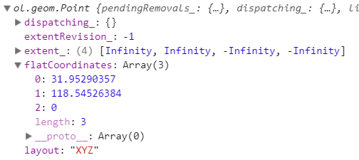
获取的data没有问题,但是经过ol.format.GML2解析后的feature出现了经纬度颠倒的情况:
查看OL4中有关ol.format.GML2读取数据的源码:
https://github.com/openlayers/openlayers/blob/2eea8df75af5f548cad4e8e0d0597e487d90a06b/src/ol/format/gml2.js#L59
https://github.com/openlayers/openlayers/blob/2eea8df75af5f548cad4e8e0d0597e487d90a06b/src/ol/format/gml2.js#L59
ol.format.GML2.prototype.readFlatCoordinates_ = function(node, objectStack) {
ol.format.GML2.prototype.readFlatCoordinates_ = function(node, objectStack) {
ol.format.GML2.prototype.readFlatCoordinates_ = function(node, objectStack) {
var s = ol.xml.getAllTextContent(node, false).replace(/^\s*|\s*$/g, '');
var context = /** @type {ol.XmlNodeStackItem} */ (objectStack[0]);
var containerSrs = context['srsName'];
var axisOrientation = 'enu';
if (containerSrs) {
var proj = ol.proj.get(containerSrs);
if (proj) {
axisOrientation = proj.getAxisOrientation();
}
}
var coordsGroups = s.trim().split(/\s+/);
var x, y, z;
var flatCoordinates = [];
for (var i = 0, ii = coordsGroups.length; i < ii; i++) {
var coords = coordsGroups[i].split(/,+/);
x = parseFloat(coords[0]);
y = parseFloat(coords[1]);
z = (coords.length === 3) ? parseFloat(coords[2]) : 0;
if (axisOrientation.substr(0, 2) === 'en') {
flatCoordinates.push(x, y, z);
} else {
flatCoordinates.push(y, x, z);
}
}
return flatCoordinates;
};enu';
if (containerSrs) {
var proj = ol.proj.get(containerSrs);
if (proj) {
axisOrientation = proj.getAxisOrientation();
}
}
var coordsGroups = s.trim().split(/\s+/);
var x, y, z;
var flatCoordinates = [];
for (var i = 0, ii = coordsGroups.length; i < ii; i++) {
var coords = coordsGroups[i].split(/,+/);
x = parseFloat(coords[0]);
y = parseFloat(coords[1]);
z = (coords.length === 3) ? parseFloat(coords[2]) : 0;
if (axisOrientation.substr(0, 2) === 'en') {
flatCoordinates.push(x, y, z);
} else {
flatCoordinates.push(y, x, z);
}
}
return flatCoordinates;
};
可以看到,在使用ol.format.GML2解析gml数据时,OL会优先使用gml数据携带的坐标系统的axis(坐标顺序)。那么再查看一下待解析的gml数据是什么样子:
unknown
JS
320100
南京0860
03
4G
118.53192755,31.99111585
可以看到,gml数据的坐标系统的名称(code)是http://www.opengis.net/gml/srs/epsg.xml#4326。这是WGS84坐标系统的code,意味着数据的坐标系统是WGS84(这与GeoServer发布的图层坐标系统吻合)。OL中默认包含该坐标系统。并且可以看到,该feature是一个点类型,其坐标顺序是(经度,纬度)。
那么再看一下OL中有关WGS84坐标系统的定义:
ol.proj.EPSG4326.PROJECTIONS = [
new ol.proj.EPSG4326.Projection_('CRS:84'),
new ol.proj.EPSG4326.Projection_('EPSG:4326', 'neu'),
new ol.proj.EPSG4326.Projection_('urn:ogc:def:crs:EPSG::4326', 'neu'),
new ol.proj.EPSG4326.Projection_('urn:ogc:def:crs:EPSG:6.6:4326', 'neu'),
new ol.proj.EPSG4326.Projection_('urn:ogc:def:crs:OGC:1.3:CRS84'),
new ol.proj.EPSG4326.Projection_('urn:ogc:def:crs:OGC:2:84'),
new ol.proj.EPSG4326.Projection_('http://www.opengis.net/gml/srs/epsg.xml#4326', 'neu'),
new ol.proj.EPSG4326.Projection_('urn:x-ogc:def:crs:EPSG:4326', 'neu')
];
同一个坐标系统可以有许多不同的code代号,以上列出的是OL中有关WGS84的所有默认code。可以看到code为http://www.opengis.net/gml/srs/epsg.xml#4326的坐标系统带了一个参数:’neu‘。该参数指明了数据的坐标顺序为(纬度,经度,高度)。
可以看出这和gml中数据的坐标顺序不一样!
下面捋一捋:使用OL的getGetFeatureInfoUrl获得的gml数据,携带有坐标系统,code为http://www.opengis.net/gml/srs/epsg.xml#4326;另外,gml数据中坐标的顺序是(经度,纬度)。
之后使用ol.format.GML2对象读取该gml数据:OL在解析的过程中,检测到了gml数据的坐标系统,因此使用了该坐标系统,即code为http://www.opengis.net/gml/srs/epsg.xml#4326的WGS84坐标系统,其axis为’neu’(纬度,经度,高度),如此,OL把gml的坐标数据(经度,纬度)当成了(纬度,经度,高度)进行处理!这导致OL最终解析出的feature的坐标出现了经纬度颠倒的情况。
解决方法
参考github上大神的方法:
it is neu according to the EPSG database
you will need to override the axis order, code sample I’ve used before:
// override the axis orientation for WMS GetFeatureInfo
var proj = new ol.proj.Projection({
code: 'http://www.opengis.net/gml/srs/epsg.xml#4326',
axis: 'enu'
});
ol.proj.addEquivalentProjections([ol.proj.get('EPSG:4326'), proj]);//也可以使用ol.proj.addProjection(proj)将新的坐标系统添加进来即可,会自动覆盖原坐标系统
解决思路就是重写(override)坐标系统的axis属性。但是需要注意的是覆盖的一定得是与gml具有相同code的坐标系统,即code为http://www.opengis.net/gml/srs/epsg.xml#4326的坐标系统。
这里附上axis的可能值及其含义:
axis可能值:enu,qnu,neu。
含义如下:
> The +axis switch takes three character arguments defining the axis
> orientation of the coordinate system. The possible values are:
>
> 'e' - easting
> 'w' - westing - an x/longitude with the opposite sign to normal.
> 'n' - northing
> 's' - southing - a y/latitude with the opposite sign to the normal.
> 'u' - up - normal z
> 'd' - down - a z/elevation with the opposite sign to the normal.
转载自:https://blog.csdn.net/a20100997/article/details/80269691
openlayers属性数据mysql_Openlayers+GeoServer+MySql获得JSON、GML数据的兼容性问题相关推荐
- openlayers属性数据mysql_OpenLayers学习笔记8——使用servlet从mysql获取数据并标注
[ { "schoolName": "城阳区第二实验中学", "schoolAddress": "山东省青岛市城阳区礼阳路107号 ...
- Mysql存储json格式数据
Mysql5.7版本以后新增的功能,Mysql提供了一个原生的Json类型,Json值将不再以字符串的形式存储,而是采用一种允许快速读取文本元素(document elements)的内部二进制(in ...
- mysql json类型数组索引_MySQL JSON 类型数据操作
1.Java 中动态扩展字段,会导致数据库表被锁,在MySQL 5.7.8版本之前,因为MySQL不能直接操作JSON类型数据,可以将一个字段设定成varchar类型,里面存放JSON格式数据,这样在 ...
- MySQL JSON 类型数据操作
1.Java 中动态扩展字段,会导致数据库表被锁,在MySQL 5.7.8版本之前,因为MySQL不能直接操作JSON类型数据,可以将一个字段设定成varchar类型,里面存放JSON格式数据,这样在 ...
- Vue中使用Openlayers加载Geoserver发布的TileWMS时单击获取shp文件的坐标信息
场景 Vue中使用Openlayers加载Geoserver发布的TileWMS: https://blog.csdn.net/BADAO_LIUMANG_QIZHI/article/details/ ...
- MybatisPlus处理Mysql的json类型
MybatisPlus处理Mysql的json类型 1.在数据库表定义JSON字段: 2.在实体类加上@TableName(autoResultMap = true).在JSON字段映射的属性加上@T ...
- mysql存json将utf8编码 去掉,MySQL对JSON类型UTF-8编码导致中文乱码探讨
原文:https://www.cnblogs.com/CreateMyself/p/12587426.html 前言 继上文发表之后,结合评论意见并亲自验证最终发现是编码的问题,但是对于字符编码还是有 ...
- Vue+Openlayers加载Geoserver发布的TileWMS后更换shp数据源的流程
场景 Vue中使用Openlayers加载Geoserver发布的TileWMS: Vue中使用Openlayers加载Geoserver发布的TileWMS_BADAO_LIUMANG_QIZHI的 ...
- Vue中使用Openlayers加载Geoserver发布的TileWMS
场景 Openlayers下载与加载geoserver的wms服务显示地图: https://blog.csdn.net/BADAO_LIUMANG_QIZHI/article/details/114 ...
最新文章
- 在Activity中响应ListView内部按钮的点击事件的两种方法
- 32 | 答疑(四):阻塞、非阻塞 I/O 与同步、异步 I/O 的区别和联系
- php 跳板机连接mysql,使用python如何通过跳板机连接MySQL数据库
- 15个优雅的Python编程技巧,掌握后瞬间玩转Python
- iOS---UICollectlionView 的使用
- 6.5 XGBoost实战
- matlab中的欧拉法,欧拉法函数
- 用友nc633与oracle,用友NC和ORACLE数据库配置教程.doc
- java计算机毕业设计企业员工工资管理系统源码+系统+数据库+lw文档+mybatis+运行部署
- 如何防止短信API接口遍历
- uva 10099【The Tourist Guide】
- Quorum企业以太坊搭建区块链记录系列
- jle汇编_JNB, JBE, JGE, JLE 指令的转移条件 5
- 使用yaf+yar实现基于http的rpc服务
- 小学生学习Python的步骤和学习周期之我见
- 201871010104-陈园园 《面向对象程序设计(java)》第四周学习总结
- 知识管理的唯一出路:与业务融合,构建情景化知识管理体系
- AR行业报告:甩掉VR,5年内AR将迎来大爆发 | 报告
- 微信小程序网悦新闻开发--功能介绍(一)
- Matlab实现Kmeans算法(每行代码标注详细注解)